
ANALISIS BANJIR DAERAH ILOTIDEA KABUPATEN GORONTALO MENGGUNAKAN DATA CITRA RADAR SRTM
Article Sidebar
Main Article Content
 http://orcid.org/0000-0003-1187-6035
Abstract
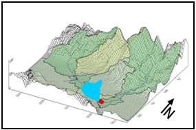
Floods are natural disasters that often occur in Indonesia, one of them in Gorontalo Province. Flood handling must begin with an understanding of flooding and geological conditions that have the potential to cause flooding. This study aims to determine the causes of flooding that occurred in the Ilotidea area based on the analysis of SRTM radar image data. SRTM data is processed and produces a 3D watershed hydrology surface model. Hydrological modeling is then carried out to obtain a 3D hydrological model on the surface of the Ilotidea region and its surroundings. Analysis of 3D watershed hydrology models and 3D hydrological models on the surface of the Ilotidea region and beyond to determine the causes of flooding in the Ilotidea region. Based on SRTM data, Ilotidea region consists of mountains morphology and lake plains. Surface modeling of 3D watershed hydrology shows that the Ilotidea region is in the Bolango watershed. The hydrological 3D surface model of the Ilotidea region shows that the flooding was caused by the overflow of Limboto Lake and Bolango River. Based on the results of the study, it can be concluded that when high-intensity rain occurs it will cause Limboto Lake and Bolango River to overflow, then causing flooding in the Ilotidea area.
Article Details

This work is licensed under a Creative Commons Attribution-NonCommercial-ShareAlike 4.0 International License.
With the receipt of the article by the Jurnal Azimut Editorial Board and the decision to be published, then the copyright regarding the article will be diverted to Jurnal Azimut.
Geography Department, Universitas Tamansiswa Padang as the publisher of Jurnal Azimut hold the copyright regarding all the published articles in this journal.
Geography Department, Universitas Tamansiswa Padang has the right to multiply and distribute the article and every author is not allowed to publish the same article that was published in this journal.
References
Badan Nasional Penanggulangan Bencana. (2017). Data kejadian bencana di indonesia. Publikasi badan nasional penanggulangan bencana [Internet]. [diakses 20 Desember 2018].
Kementrian Kesehatan Indonesia. (2018). Banjir Bandang Di Gorontalo, Gorontalo, 16-04-2018 [Internet].
[diakses 21 Desember 2018]
Mahmudi, M., Subiyanto, S., Darmo Yuwono, B., Prasetyo, Y. and Sukmono, A., (2015). Analisis Ketelitian Dem Aster Gdem, Srtm, Dan Lidar Untuk Identifikasi Area Pertanian Tebu Berdasarkan Parameter Kelerengan (Studi Kasus: Distrik Tubang, Kabupaten Merauke, Provinsi Papua. Dissertation. 2015. Semarang: Universitas Diponegoro.
Tolodo, D.D., Suma, M.D., Yusuf, N.J. and Manyoe, I.N., (2019). Subsurface Structure Identification In Ilotidea Using Electrical Method For Developed The Flood Tourist Science Village. Jurnal Sains Informasi Geografi, 2(1), pp.44-49.