
ASESMEN NILAI-NILAI PARIWISATA TERHADAP FITUR GEOLOGI DAERAH BONGO DAN SEKITARNYA SEBAGAI DASAR PENGEMBANGAN GEOWISATA DI PESISIR SELATAN GORONTALO
Article Sidebar
Main Article Content
 http://orcid.org/0000-0003-1187-6035
Ivan Taslim, Mr
Emi Prasetyawati Umar, Miss
Tedy Harianto Salama, Mr
Siti Suhartini Napu
http://orcid.org/0000-0003-1187-6035
Ivan Taslim, Mr
Emi Prasetyawati Umar, Miss
Tedy Harianto Salama, Mr
Siti Suhartini Napu
Abstract
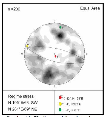
Geology is an important aspect in the development of tourism in an area. One of the attractions in a natural tourism location is certainly highly controlled by the geological setting in the area. The purpose of this research is to assess tourism values of geological features in the Bongo and surrounding areas as a basis for developing geotourism on the southern coast of Gorontalo. The research location is at coordinates N 00029’42” - N 00029’51” and E 12301’26” - E 12303’32”. The method used in this study is a surface geological survey, which includes field data collection in the form of lithology, geological structure and geomorphology. The standard used for assessing tourism values is the technical guide for assessing geological heritage resources by the Geological Survey Center. The results showed that the lithology unit of the study area consists of granite, volcanic breccia and reef limestone. The geological structure in the research area is shear fracture with main stress that relatively directed to northwest-southeast. The geomorphic unit of the study area consisted of two units, namely volcanic hills, and marine units. The results of the assessment of tourism values on geological features explain that the Bongo and surrounding areas are included in the medium category. Improvements are needed on low value criteria, namely vulnerability, relationships with other values, and economic level.
Article Details

This work is licensed under a Creative Commons Attribution-NonCommercial-ShareAlike 4.0 International License.
With the receipt of the article by the Jurnal Azimut Editorial Board and the decision to be published, then the copyright regarding the article will be diverted to Jurnal Azimut.
Geography Department, Universitas Tamansiswa Padang as the publisher of Jurnal Azimut hold the copyright regarding all the published articles in this journal.
Geography Department, Universitas Tamansiswa Padang has the right to multiply and distribute the article and every author is not allowed to publish the same article that was published in this journal.
References
Badan Pusat Statistik Kabupaten Gorontalo. 2018. Kabupaten Gorontalo dalam Angka 2018. BPS Kabupaten Gorontalo, Gorontalo
Dunham, R.J. 1962. Classification of Carbonate Rocks According to Depositional Texture, Classification of Carbonate Rocks—A Symposium, William E. Ham.
Manyoe, I.N. 2019. Geologi dan Manifestasi Thermal Libungo. UNG Press, Gorontalo.
Pusat Survei Geologi. 2017. Petunjuk Teknis Asesmen Sumberdaya Warisan Geologi. Bandung: Badan Geologi.
Schmid, R. 1981. Descriptive nomenclature and classification of pyroclastic deposits and fragments: Recommendations of the IUGS Subcommission on the Systematics of Igneous Rocks. Geology; 9 (1): 41–43. doi: https://doi.org/10.1130/0091-7613(1981)9<41:DNACOP>2.0.CO;2.
Surmont, J., Laj, C., Kissel, C., Rangin, C., Bellon, H., & Priadi, B. (1994). New paleomagnetic constraints on the Cenozoic tectonic evolution of the North Arm of Sulawesi, Indonesia. Earth and Planetary Science Letters, 121, 629-638.
Travis, R. B., & Colorado School of Mines. (1955). Classification of rocks. Golden, Colo: Colorado School of Mines.
Zuidam, R. A. van. (1986). Aerial photo-interpretation in terrain analysis and geomorphologic mapping. The Hague : Smits, Publishers.