
STUDI TINGKAT BAHAYA BANJIR DAS BATANG KURANJI KECAMATAN PAUH KOTA PADANG
Article Sidebar
Main Article Content
Abstract
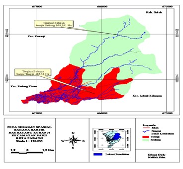
High rainfall with human factor make happen change characteristic especially at upper zone cause batang Kuranji stream. This research was conducted with the aim of 1) determine the characteristics of land Batang Kuranji Pauh sub district 2) determine the level of flood hazard Batang Kuranji Pauh sub district 3) analyze the spatial distribution of flood hazard Watershed (DAS) Batang Kuranji Pauh sub district. The results showed that: 1) there are differences in the characteristics of the land (land form, slope of land, damming of river, river meanders, the average slope of the watershed, land use, rainfall, soil texture and soil permeability) of each area of research that could potentially trigger flooding, 2) High level of flood hazards present in the study area with the Land Force (a) F1.Qal.I.pm.Al, (b) F1.Qal.I.Sw.Al, (c) F1.Qal.III.Kc.Lat, (d) F2.Qf.I.Kc.Lat, (e) F2.Qf.I.Pm.Al, (f) F2.Qf.I.Pm.Lat, (g) F2.Qf.I.SwAl, (h) F2.Qf.III.Ht.And, (i) V1.QTau.III.Pm.Lat, (j) V1.QTauIII.Pm.Lat, The study area has a moderate flood level of hazard present in the study area with land units (a) V1.QTau.III.Ht.Lat, (b) V1.QTau.III.Pm.Al, (c) V1.QTau.III.H.And. 3) The area of research that has a high level with a broad floods 486.58 Ha. And a research area with moderate flood hazard level has an area of 998.391 Ha.
Article Details

This work is licensed under a Creative Commons Attribution-NonCommercial-ShareAlike 4.0 International License.
With the receipt of the article by the Jurnal Azimut Editorial Board and the decision to be published, then the copyright regarding the article will be diverted to Jurnal Azimut.
Geography Department, Universitas Tamansiswa Padang as the publisher of Jurnal Azimut hold the copyright regarding all the published articles in this journal.
Geography Department, Universitas Tamansiswa Padang has the right to multiply and distribute the article and every author is not allowed to publish the same article that was published in this journal.
References
BPDAS Agam Kuantan
Haryanto, E. 2001. Perubahan Penggunaan Lahan Dan Implikasinya Terhadap Koefesien Air Aliran DAS Citarum Hulu Jawa Barat. Penelitian Universitas Padjadjaran.
Hermon, D. 2012. Mitigasi Bencana Hidrometeorologi. UNP Press. Padang
Kodoate, J.R., dan R. Syarief. 2008. Pengelolaan Sumber Daya Air Terpadu. Andi offset. Yogyakarta
Muryono. 2008. Arahan Fungsi Pemanfaatan Lahan Daerah Aliran Sungai Samin Kabupaten Karanganyar Dan Kabupaten Sukoharjo Tahun 2007. Skripsi. Surakarta : Universitas Sebelas Maret
Paimin, sukresno, dan I.B pramono.2009. Teknik Mitigasi Banjir Dan Tanah Longsor. Tropenbos Internasional Indonesia programe