
Uji Akurasi Klasifikasi Terbimbing Berbasis Piksel Pada Citra Sentinel 2-A Menggunakan Citra Tegak Resolusi Tinggi Tahun 2019 di Kota Padang
Article Sidebar
Main Article Content
Abstract
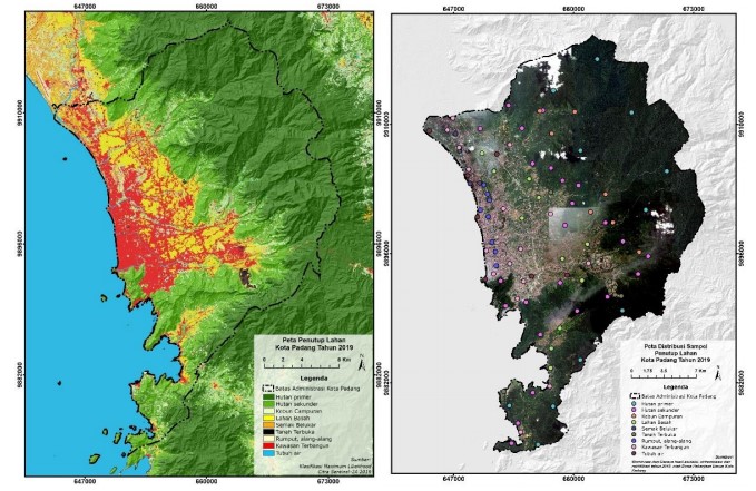
Currently, land cover data sourced from satellite imagery are increasingly being used with advances in sensing technology that are increasingly sophisticated. Maximum likelihood is one of the digital image classification methods that have long been used for pixel-based image classification. This study aims to classify land cover on Sentinel-2A satellite imagery using the maximum likelihood method to see the level of accuracy in that method. The accuracy test is carried out by comparing the results of the classification of the land cover map on the Sentinel-2A image with the sample in the High Resolution Upright Image with the acquisition date which is said to be Worldview and Geoeye imagery in 2019. From the classification results obtained an overall value of 90.81% with the type of land cover highest level of accuracy is wetlands and built-up areas. Meanwhile, the type of cover with the lowest accuracy or the most errors occurred in mixed garden types.
Article Details

This work is licensed under a Creative Commons Attribution-NonCommercial-ShareAlike 4.0 International License.
With the receipt of the article by the Jurnal Azimut Editorial Board and the decision to be published, then the copyright regarding the article will be diverted to Jurnal Azimut.
Geography Department, Universitas Tamansiswa Padang as the publisher of Jurnal Azimut hold the copyright regarding all the published articles in this journal.
Geography Department, Universitas Tamansiswa Padang has the right to multiply and distribute the article and every author is not allowed to publish the same article that was published in this journal.
References
Bruce, C.M. and Hilbert, D.W. 2006. Pre-Processing Methodology for Application to Landsat TM/ETM+ Imagery of the Wet Tropics. Research Report. Rainforest Cooperative Research Center for Tropical Rainforest Ecology and Management, Australian Cooperative Research Centres Programs (CRC). www.rainforest-crc.jcu.edu.au
Danoedoro, P., 2012, Pengantar Penginderaan Jauh Digital, Penerbit Andi, Yogyakarta.
Huang, S.L. Wang, S.H. & Budd, W.W. 2009. Sprawl in Taipei’s Peri-Urban Zone: Responses to Spatial Planning and Implications for Adapting Gobal Environmental Change. Landscape and Urban Planning, 90 (1-2), pp. 20-32
Jensen, J.R., 2005, Introductory Digital Image Processing: A Remote Sensing Perspective, Third Edition, Pearson Education, Inc., United States of America
Reis, S. 2008. Analyzing Land Use/Land Cover Changes Using Remote Sensing and GIS in Rize, North-East Turkey. Sensors, 8(10), pp. 6188-62202
Song, C. Woodcock, C.E. Seto, K.C. Lenney, M.P. and Scott, A.M. 2001. Classification and Change Detection Using Landsat TM Data; When and How to Correct Atmospheric Effect?. Remote Sensing of Environment 75, pp. 230-244
Richards, J.A & Jia, X. 2006. Remote Sensing Digital Image Analysis; An Introduction. Berlin, Germany: Springer
Short, N. M. (1982). The landsat tutorial workbook — Basics of satellite remote sensing. Greenbelt, Md., Goddard Space Flight Center, NASA Reference Publication 1078.
Sutanto, 1986. Penginderaan Jauh Dasar (Jilid I). Fakultas Geografi, Universitas Gadjah Mada
Sutanto, 1994. Penginderaan Jauh Dasar (Jilid II). Fakultas Geografi, Universitas Gadjah Mada