
Sebaran Spasial Terumbu Karang Di Suwarnadwipa Kecamatan Bungus Teluk Kabung Kota Padang
Article Sidebar
Main Article Content
Abstract
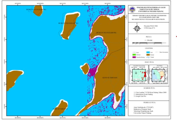
Coral reef mapping aims to see the distribution of coral reefs from 2000, 2010 and 2020. In addition, coral reef mapping also aims to see changes in the extent and damage of coral reefs from 2000, 2010 and 2020. The method used to detect the distribution of coral reefs is lyzenga logarithmic method, while to detect damage to coral reefs the method used is the unsupervised classification method. The lyzenga logarithm method uses attenuation coefficients based on the sharpening of the pixel spectral value to a certain depth to increase the value of the reflection of coral reef objects and the unsupervised classification method uses the sensitivity of the spectral values of each pixel to coral reef objects. The results of the interpretation there was a significant change in the area of coral reefs from 2000 to 2010 and 2010 to 2020. The interpretation of images from 2000 to 2010 detected a decrease in the area of 1.19 hectares. In 2010 to 2020 it detected a decrease in area of 28.87 hectares. The classification results detected an increase in the area of damaged coral reefs from 2010 to 2020 as much as 8.74 hectares. The two methods used have differences in the level of accuracy, the lyzenga logarithmic method has an accuracy rate of 88.89% while the unsupervised classification method shows an accuracy of 86.12% so the lyzenga logarithmic method is the most suitable method for detecting coral reefs in Suwarnadwipa, Bungus Teluk District. Kabung City of Padang.
Article Details

This work is licensed under a Creative Commons Attribution-NonCommercial-ShareAlike 4.0 International License.
With the receipt of the article by the Jurnal Azimut Editorial Board and the decision to be published, then the copyright regarding the article will be diverted to Jurnal Azimut.
Geography Department, Universitas Tamansiswa Padang as the publisher of Jurnal Azimut hold the copyright regarding all the published articles in this journal.
Geography Department, Universitas Tamansiswa Padang has the right to multiply and distribute the article and every author is not allowed to publish the same article that was published in this journal.
References
Daniel, Dirga. 2010. Karakteristik Oseanografis dan Pengaruhnya Terhadap Distribusi dan Tutupan Terumbu Karang di Wilayah Gugusan Pulau Pari, Kabupaten Kepulauan Seribu, DKI Jakarta.
Darwin. 1842. Ekosistem Terumbu Karang dan Statusnya (Studi Kasus Kondisi Terumbu Karang di Provinsi Bali).
Didi, La, Diyah Palupi, and Kecamatan Wangi-wangi Kabupaten. 2018. “Pemetaan Kondisi Terumbu Karang Menggunakan Citra Satelit Di Pulau Matahora Kabupaten Wakatobi.” 3(4): 319–26.
Dominggus, Samuel,dkk. 2016. Pemantauan Ekosistem Terumbu Karang Menggunakan Data Penginderaan Jauh Studi Kasus di Pulau Owi, Papua. Prosedia Ilmu Lingkungan Hidup. 33(3): 600-606.
Fadhli, Rafdi. 2018. Persebaran Terumbu Karang di Wilayah Perairan Karawang. Jurnal Geografi Lingkungan Tropik. 2(1): 38-51.
Johan, Irawan. 2017. Studi Perkembangan Terumbu Karang di Peraiaran Pulau Panjang Jepara Menggunakan Citra Sentinel-2 Menggunakan Logaritma Lyzenga.
Lyzenga, Metode Algoritma. 2018. Jurnal Geodesi Undip Oktober 2018 (7): 233–43.
Verwey. 1981. Kondisi Terumbu Karang di Tanjung Gosongseng Desa Kahyapu Pulau Enggano Provinsi Bengkulu. 1(1): 43-56.
Yempita, Efendi. 1994. Kerusakan Terumbu Karang di Perairan Sepanjang Pantai Sumatera Barat. Jurnal Perikanan Laut. (91): 48-56.