PENENTUAN KERAWANAN BENCANA LONGSOR BERBASIS GIS DI KABUPATEN PESISIR SELATAN
Main Article Content
Abstract
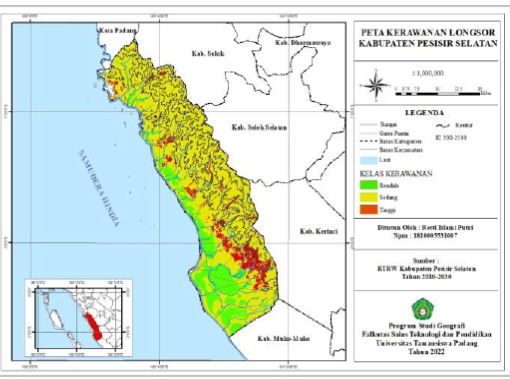
The purpose of this study was to determine the distribution of landslide-prone areas and evaluate the suitability of spatial patterns based on landslide vulnerability in Pesisir Selatan Regency. The method is quantitative and descriptive using score classification and parameter weighting used, based on the Puslittanak method (2004). To evaluate the suitability of an area's spatial pattern for landslide hazard using a GIS-based overlay method (ArcGIS 10.3 software). Based on the results of the study, it can be concluded that the Pesisir Selatan region has a low landslide vulnerability of 125788,3 ha (21%), a moderate landslide vulnerability of 455685,8 ha (76%), covering 15 sub-districts, and a high. prone to landslides covering an area of 20293 ha (3%) covering 14 districts. The landslide susceptibility map shows 67% suitable and 33% not suitable. Suitable are advised not to carry out new developments or expansion of land use, and areas that are not suitable need to revise regional spatial patterns, especially in areas prone to high landslides.
Article Details

This work is licensed under a Creative Commons Attribution-NonCommercial-ShareAlike 4.0 International License.
With the receipt of the article by the Jurnal Azimut Editorial Board and the decision to be published, then the copyright regarding the article will be diverted to Jurnal Azimut.
Geography Department, Universitas Tamansiswa Padang as the publisher of Jurnal Azimut hold the copyright regarding all the published articles in this journal.
Geography Department, Universitas Tamansiswa Padang has the right to multiply and distribute the article and every author is not allowed to publish the same article that was published in this journal.
References
Adria, M.W 2016, Analisis Bahaya Longsor Di Kecamatan Bayang Utara Kabupaten Pesisir Selatan Sumatera Barat, Jurnal Geografi Vol, 8 No 1.
BNPB. 2012. Peraturan Kepala Badan Nasional Penanggulangan Bencana Nomor 2 Tahun 2012, Tentang Pedoman Umum Pengkajian Risiko Bencana, Jakarta: BNPB.
BNPB. 2019 Katalog Desa/Kelurahan Rawan Tanah Longsor (Kelas Rawan Longsor Rendah Dan Tinggi). Jakarta. BNPB.
Gusrizal. (2021) Longsor Melanda Pesisir Selatan, Akses Jalan Nasional Terputus, https:/galamedia.pikiran-rakyat.com/news/pr-353258996/longsormelanda-pesisir-selatan-akses-jalan-nasional-terputus.
https://glovis.usgs.gov/, (Citra Satelit Landsat 8 tahun 2021).
Https://M.Republika.Co.Id.Amp/Qmpngy463 Gambar Nagari Gantiang Mudiak Utara Surantih, Kec Sutera .
Ismayani, Nina., dkk. 2021. Klasifikasi lahan kawasan Rawan Longsor di Kecamatan Koto Parik Gadang Diateh Kabupaten Solok Selatan. Jurnal Georafflesia, Vol., 6 No.1.
Kamil, A., Poli, H., Dan Karongkong, H, H. 2014. Kajian Pemanfaatan Lahan Pada Daerah Rawan Longsor Di Kecamatan Tikala Kota Manado, Jurnal Penelitian Sabua, Volume 2, No. 2 : 215-222.
Peraturan Menteri Pekerjaan Umum: 22/PRT/M/2007 tentang Pedoman Tata Ruang Wilayah Longsor : Jakarta.
Puslittanak. Pusat Penelitian Dan Pengembangan Tanah Dan Agroklimat. (2004). Laporan Akhir Pengkajian Potensi Bencana Kekeringan, Banjir Dan Longsor Di Kawasan Satuan Wilayah Sungai Citarum-Ciliwung, Jawa Barat Bagian Barat Berbasis Sistem Informasi Geografi. Bogor .
Pusat Vulkanologi Dan Mitigasi Bencana Geologi, 2012. Gerakan Tanah, Bandung : Kementrian ESDM.
Rahmad, R. Suib. dan Ali, N. 2018. Aplikasi SIG Untuk Pemetaan Tingkat Ancaman Longsor Di Kecamatan Sibolangit, Kabupaten Deli Serdang, Sumatera Barat. Majalah Geografi Indonesia Volume 32, No.1, 1-1.
Suryana, A. S., Reski, N., Arsyad, U., Wahyuni. Bachtiar, B. 2021. Analisis Kesesuaian Penggunaan Lahan Terhadap Pola Ruang Di Daerah Aliran Sungai Bialo. J. Agroplantae, Vol 10. No.1.
Wardhani, Dena Prapanca. 2021. Penentuan Jalur Alternatif Menghindari Daerah Rawan Longsor Menggunakan Sistem Informasi Geografis (Studi Kasus: Kabupaten Pesisir Selatan, Sumatera Barat). Jurnal Institut Teknologi Sepuluh November.
Yunianto, AC 2011, Analisis Bahaya Longsor Menggunakan Sistem Informasi Geografis (SIG) dan Penginderaan Jauh Kabupaten Bogor, skripsi, Bogor.

